

 68
68  When I had just started my sea career, I never understood how the depths of the entire ocean was measured.
I mean 70% of the earth is covered with water. How was this nearly impossible task of measuring the depths achieved?
Over the years I realized that it was not done in few days and not by few men.
This task is ever going since hundreds of years and the hydrographic offices of the countries are conducting these surveys regularly.
The only thing that has changed over the years is the method of conducting these surveys.
In early days the survey was done with hand-lead lines and single beam echo sounders.
It then changed to the wire-drag method where a wire was dragged by two or more ships with weights submerged to the fixed depth.
When I had just started my sea career, I never understood how the depths of the entire ocean was measured.
I mean 70% of the earth is covered with water. How was this nearly impossible task of measuring the depths achieved?
Over the years I realized that it was not done in few days and not by few men.
This task is ever going since hundreds of years and the hydrographic offices of the countries are conducting these surveys regularly.
The only thing that has changed over the years is the method of conducting these surveys.
In early days the survey was done with hand-lead lines and single beam echo sounders.
It then changed to the wire-drag method where a wire was dragged by two or more ships with weights submerged to the fixed depth.
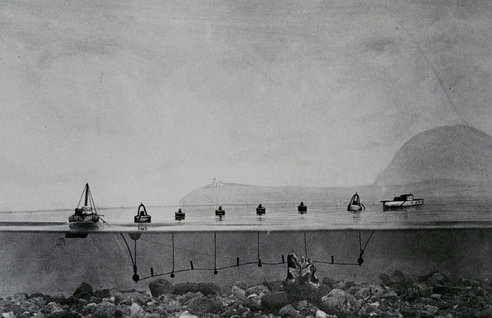 Any obstruction in the area covered would be detected by the wire getting stretched.
The modern technique uses SONAR multi-beam waves to record the depths. The collected data is processed through other data like tide to get the depth as accurate as possible.
This method, of course, would give more accurate depths.
So Let is sa...
Any obstruction in the area covered would be detected by the wire getting stretched.
The modern technique uses SONAR multi-beam waves to record the depths. The collected data is processed through other data like tide to get the depth as accurate as possible.
This method, of course, would give more accurate depths.
So Let is sa...
Join now to access this article and much more.
Admin has placed this article behind a paywall, making it accessible only with a paid membership, which offers numerous perks:
- Contribute to creating a platform for reading and writing without ads.
- Enjoy all content here, including exclusive articles for members.
- Gain access to all exclusive articles for members.

About Capt Rajeev Jassal
Capt. Rajeev Jassal has sailed for over 24 years mainly on crude oil, product and chemical tankers. He holds MBA in shipping & Logistics degree from London. He has done extensive research on quantitatively measuring Safety culture onboard and safety climate ashore which he believes is the most important element for safer shipping.


Comments (68)